
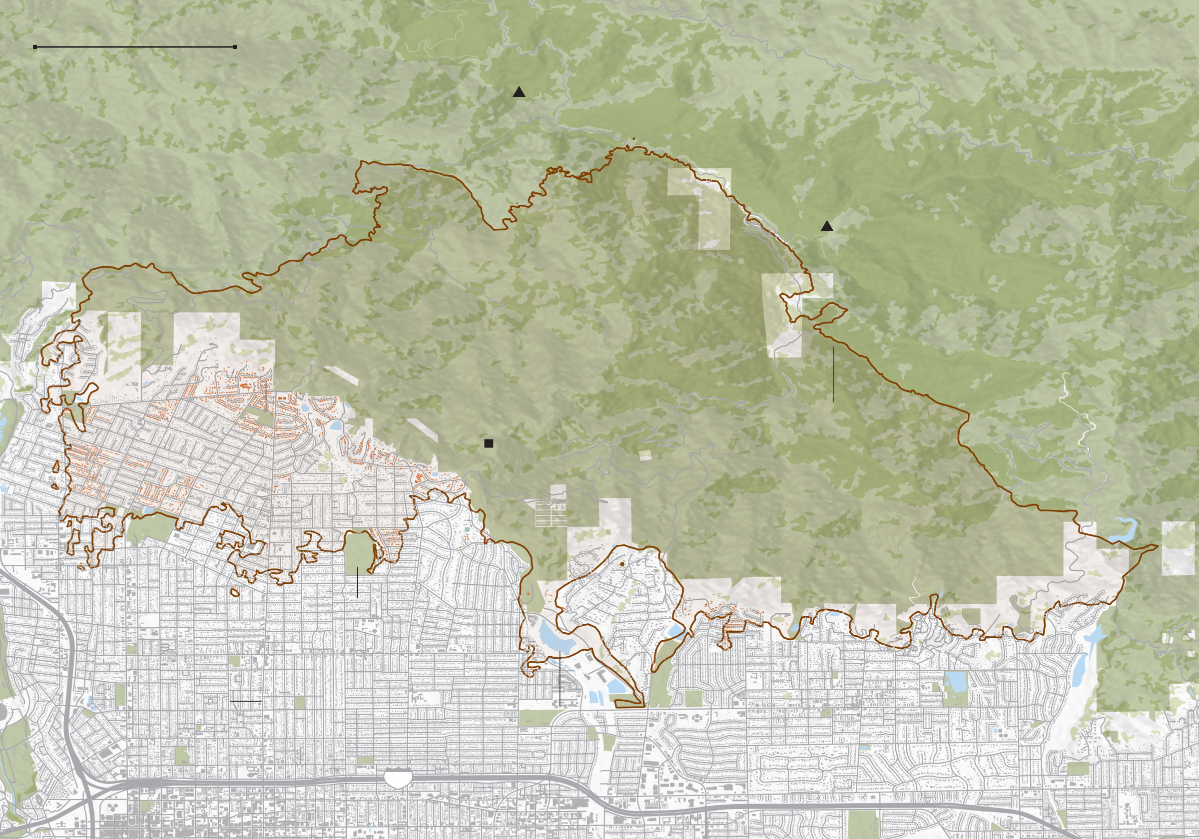
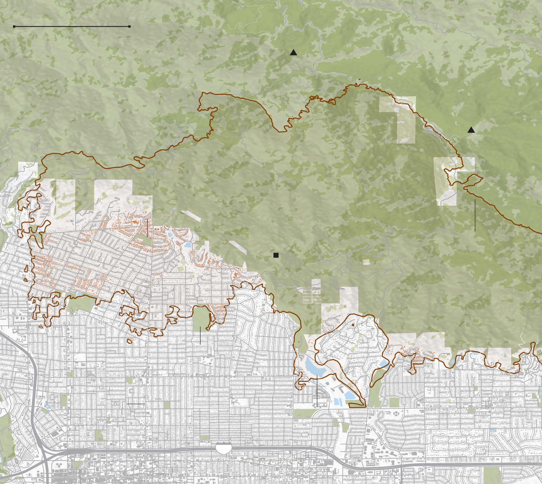
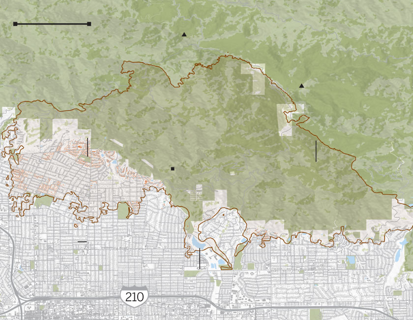
Ten days after Los Angeles’ unprecedented firestorm began, the Eaton and Palisades fires consumed nearly 40,000 acres of homes, businesses and landmarks in Altadena and the Pacific Palisades and killed at least two dozen people.
Both fires now rank among the 10 most destructive in California history and the most costly in U.S. history. Fire crews have yet to fully contain the blazes. As of Wednesday evening, the Eaton fire was 45% contained. The Palisades fire was 21% contained.
Aerial surveys estimate more than 7,000 structures are destroyed in the Eaton fire and more than 5,000 structures in the Palisades fire, according to CalFire.
On the ground, dozens of teams are assessing the damage building by building, home by home. Everything larger than 120 square feet is included in their reports. So far, about 50% of the structures within the Eaton fire perimeter have been inspected, and 35% of buildings in the Palisades.
These maps track the structures that have been classified so far as destroyed or damaged. They will be updated periodically as officials complete their work.

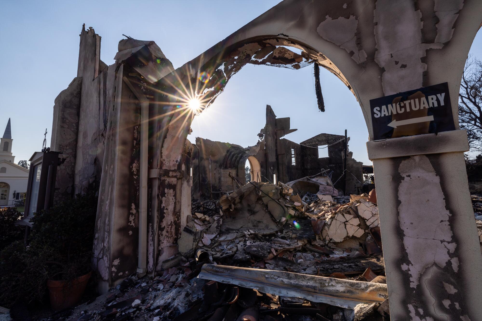
Most of the buildings affected were single-family residences. In Altadena, community fixtures such as the Pasadena Jewish Temple and Center and Saint Mark’s Episcopal Church burned to the ground. Coastal landmarks in the Palisades and Malibu — Reel Inn and Cholada Thai — were consumed by flames. Schools were gutted.
Eaton fire
Extent of damage
Affected (1-10% damaged)
Minor (10-25%)
Major (25-50%)
Destroyed (50-100%)
1.5 MILES
SAN GABRIEL
PEAK
MT. WILSON
OBSERVATORY
SAN GABRIEL MOUNTAINS
Charles S.
Farnsworth
Park
Eaton fire
perimeter
EATON CANYON FALLS
Altadena
Kinneloa Mesa
Normandie
Heights
ALTADENA
GOLF COURSE
Sierra Madre
Pasadena
North Lake
Avenue
Eaton Canyon
Reservoir
Arcadia
210
1.5 MILES
SAN GABRIEL
PEAK
MT. WILSON
OBSERVATORY
SAN GABRIEL MOUNTAINS
Charles S.
Farnsworth
Park
Eaton fire
perimeter
EATON CANYON FALLS
Altadena
Kinneloa Mesa
Normandie
Heights
ALTADENA
GOLF COURSE
Sierra Madre
Pasadena
North Lake
Avenue
Eaton Canyon
Reservoir
210

1.5 MILES
SAN GABRIEL
PEAK
MT. WILSON
OBSERVATORY
Charles S.
Farnsworth Park
SAN GABRIEL MOUNTAINS
Eaton fire
perimeter
EATON CANYON FALLS
Altadena
Kinneloa Mesa
Normandie
Heights
ALTADENA
GOLF COURSE
Sierra Madre
North Lake
Avenue
Pasadena
Eaton Canyon
Reservoir
Arcadia
210
1.5 MILES
SAN GABRIEL MOUNTAINS
SAN GABRIEL
PEAK
MT. WILSON
OBSERVATORY
Charles S.
Farnsworth Park
EATON
CANYON
FALLS
Eaton fire
perimeter
Altadena
North
Lake
Avenue
Sierra Madre
Pasadena
Eaton Canyon
Reservoir
Arcadia
LOS ANGELES TIMES
Early in the evening of Jan. 7, Altadena and Pasadena residents saw flames in the distance at Eaton Canyon — an area known for horseback riding, hiking trails, streams and wild animals. The earliest reports indicated that the fire was modest but it ballooned in hurricane-strength wind conditions, ultimately swallowing up more than 14,000 acres as it spread through neighborhoods, destroying thousands of structures and taking the lives of at least 16.
A power outage had left much of the area pitch-black. Tens of thousands of residents were ordered to evacuate. As powerful winds grew, some stayed to fight flames from their roofs while others fled, navigating their way from home without working traffic lights amid flying debris. Residents of a senior home were rushed to safety.
By 3 a.m., the fire had moved east to west. Embers rained down as more residents escaped while their streets burned behind them.
The next morning, many returned to find their homes crumbled or on fire. Desperate, they sprayed flames with hoses and tried to prevent embers from flying again as firetrucks were sparse. The lucky ones whose houses stood coped with survivors’ guilt, unsure why their home was spared when others were not.
In Altadena, Maral Nazarian, 60, watched in tears as the remnants of her house burned. She grew up in the rustic town; this disaster was incomprehensible.
“We never expected this. We thought we were far enough from the hills,” she said in disbelief.
Altadena sits above Pasadena, nestled against the foothills of the mountains. But it isn’t considered a traditional mountain town.
The fire left longtime residents in shock that it made it so far south, leaving many residents who live and work in the community without home or income. Nearly 42,000 people live in the largely working-class neighborhood.
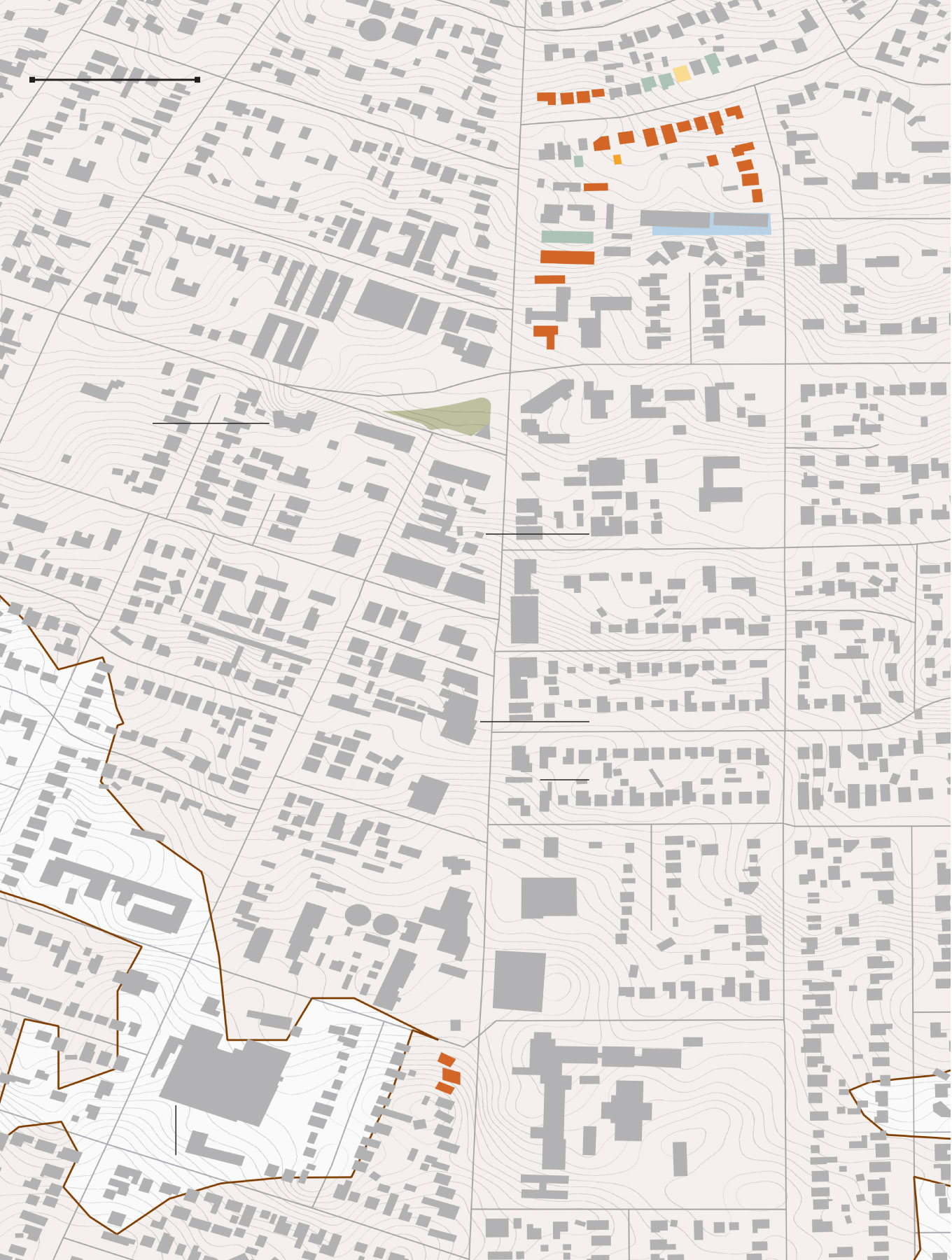
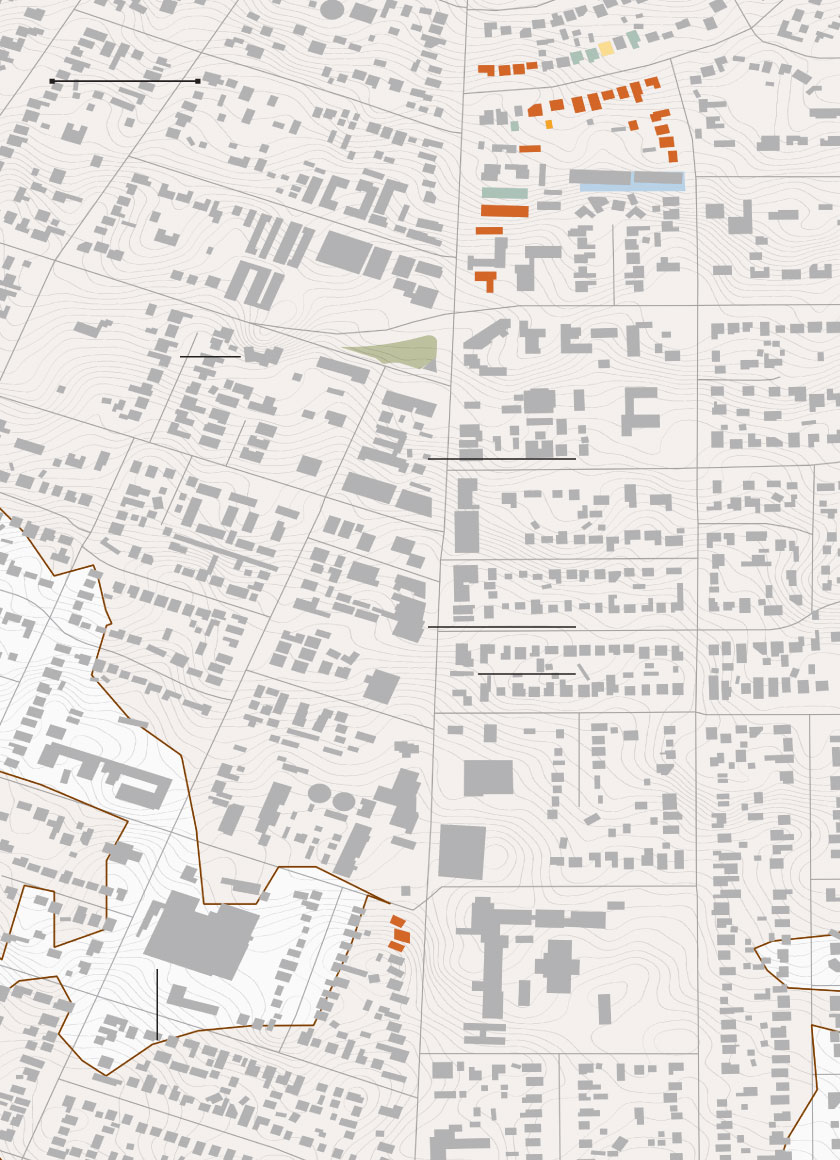
It destroyed the area’s first main business district on North Lake Avenue, demolishing longtime fixtures such as Altadena Hardware and Fox’s; Steve’s Pets and the Rancho. It gutted the Aldi grocery store, nearby schools and churches. Farther north, the buildings at the historic Charles S. Farnsworth Park were gone.
500 FEET
North Lake Avenue
THE BUNNY
MUSEUM
East Altadena Drive
SAINT MARK’S
EPISCOPAL
CHURCH
ALTADENA
COMMUNITY
CENTER
RANCHO BAR
STEVE’S PETS
FOX’S RESTAURANT
ALDI
ELIOT ARTS
MAGNET
MONTECEDRO
RETIREMENT
COMMUNITY
500 FEET
North Lake Avenue
THE BUNNY
MUSEUM
East Altadena Drive
SAINT MARK’S
EPISCOPAL
CHURCH
ALTADENA
COMMUNITY
CENTER
RANCHO BAR
STEVE’S PETS
FOX’S RESTAURANT
ALDI
ELIOT ARTS
MAGNET
MONTECEDRO
RETIREMENT
COMMUNITY
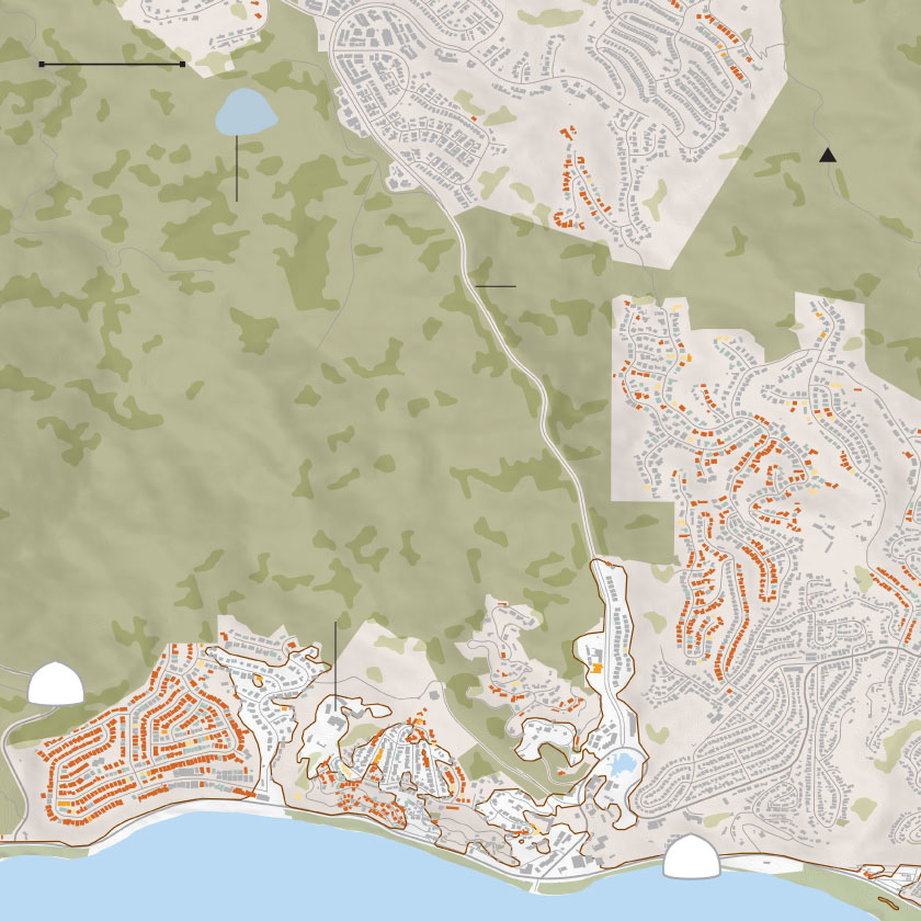
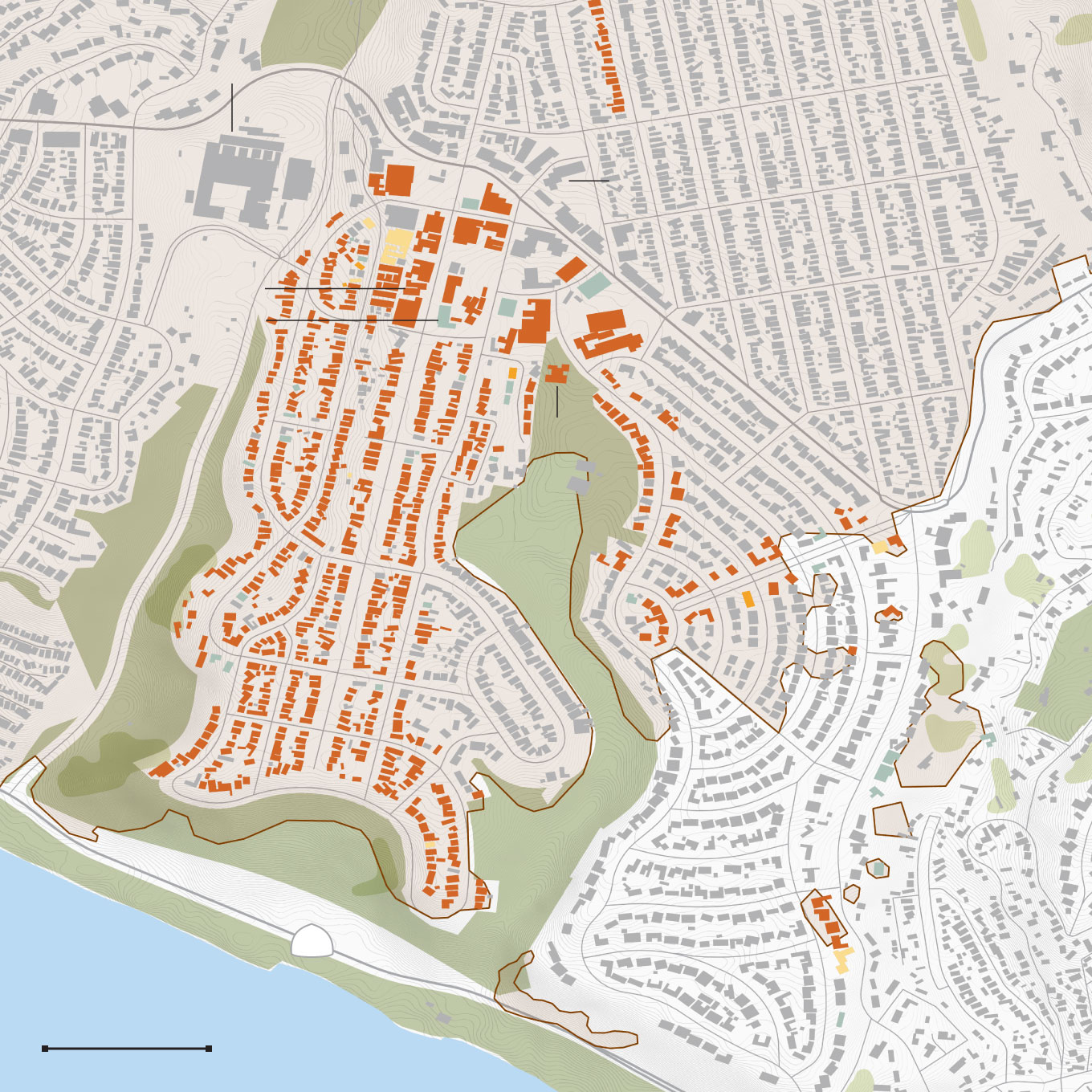
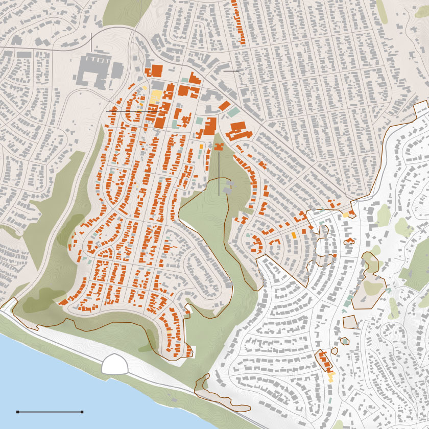
A building shown in gray does not necessarily mean it is un-damaged; it could be awaiting assessment. Approximately half of the Eaton fire area buildings have been inspected. These maps will be updated periodically as officials complete their work.
LOS ANGELES TIMES
Less than two miles west on North Fair Oaks Ave., the fire destroyed more Altadena staples including the beloved Little Hen Coffee Shop and a newer neighborhood favorite, Pizza of Venice.

500 FEET
COBB ESTATE
TRAILHEAD
PASADENA
ROSEBUD
ACADEMY
E. Loma Alta Drive
Lake Ave.
Charles S.
Farnsworth
Park
500 FEET
COBB
ESTATE
TRAILHEAD
PASADENA
ROSEBUD
ACADEMY
E. Loma Alta Drive
N. Lake Avenue
Charles S.
Farnsworth
Park
LOS ANGELES TIMES
Farther east, a historic Pasadena synagogue was left shattered.
In between and all around, the fire left a wake of disaster. In certain parts, it wiped away entire neighborhood blocks.
Gonzalo M., 53, had driven for three days from Arizona to check on his home in Altadena where he grew up and where his mother still lived. His mom was evacuated by a neighbor and was safe. But the house he’d known his entire life was destroyed, along with the others on his street.
A fire hydrant had been installed on the corner of his block in recent years as California’s brush fires have grown. Gonzalo doesn’t know if it was used, or if the water had run out.
“It’s devastating,” he said. “You work so hard for all this stuff. It’s terrible.”
By Jan. 9, much of the area had been barricaded. The National Guard and law enforcement stationed themselves at most entry points to the neighborhoods where downed power lines and trees, debris and ash filled the streets.
Officials are still investigating the cause of the fire. An area around a Southern California Edison electrical transmission tower in Eaton Canyon has become a focus of their inquiry.
Thousands remained under evacuation order.
Inside the Pasadena Convention Center, at hotels, and on friends’ and families’ couches, residents found shelter. But they remained displaced, unsure of when they could return to see their home, sort through the remains of what was left of their land or confirm their worst fears: that their house is gone.
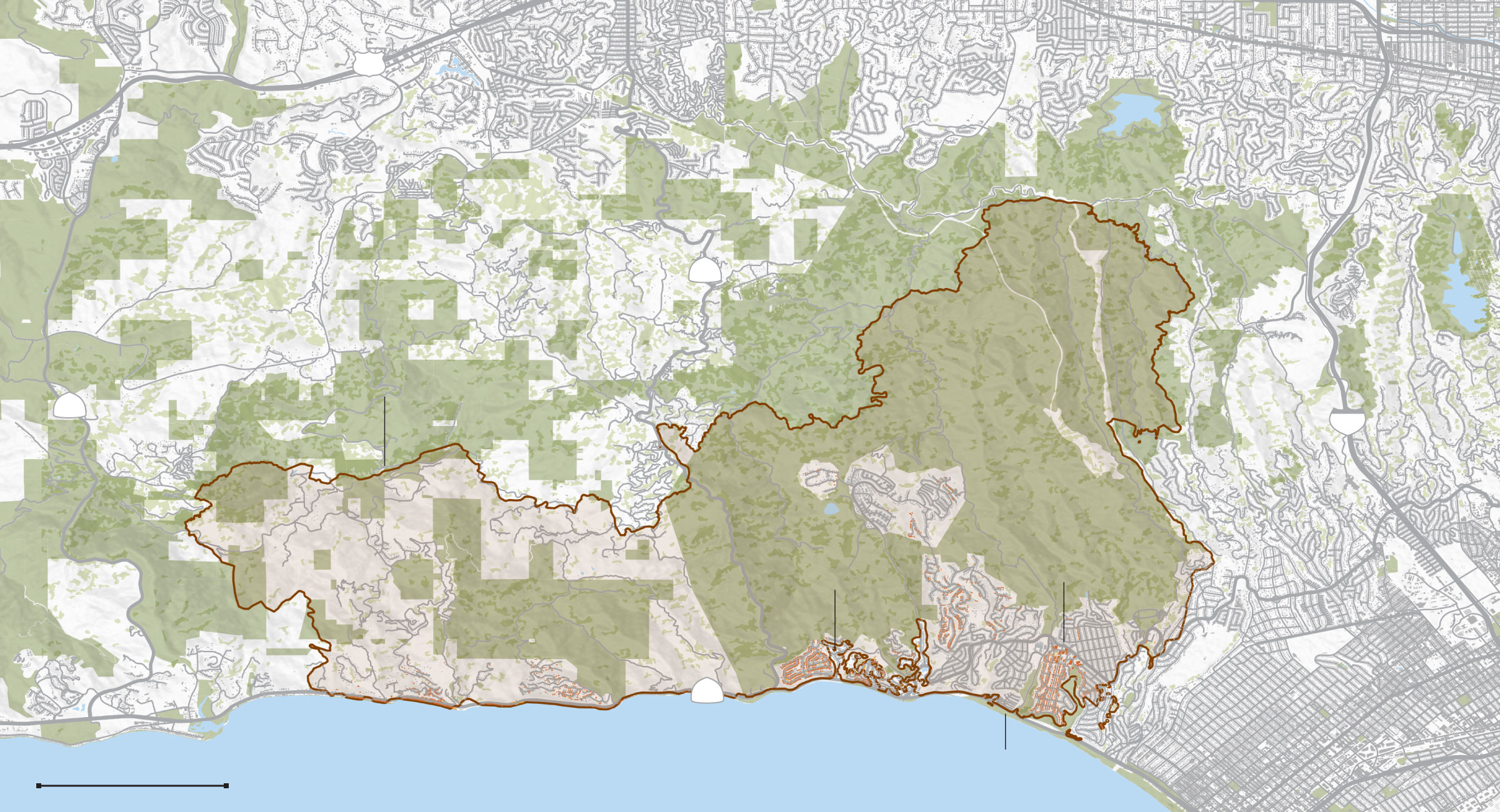
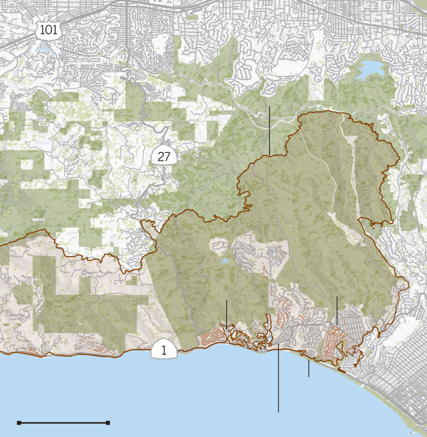
PALISADES
Extent of damage
Affected (1-10% damaged)
Minor (10-25%)
Major (25-50%)
Destroyed (50-100%)
101
Encino
Sherman Oaks
Calabasas
SANTA MONICA MOUNTAINS
27
Palisades fire
perimeter
Topanga State Park
Topanga
23
405
Pacific Palisades
PALISADES
VILLAGE
GETTY
VILLA
Brentwood
Sunset
Boulevard
Big Rock
1
Topanga
Beach
Malibu
Will Rogers
State Beach
Pacific Ocean
2 MILES
Santa Monica
Encino
Calabasas
Palisades fire
perimeter
Topanga
Pacific Palisades
PALISADES
VILLAGE
GETTY
VILLA
Big Rock
Pacific Ocean
Will Rogers
State Beach
2 MILES
Sunset Boulevard

Encino
Calabasas
SANTA MONICA MOUNTAINS
27
Palisades fire
perimeter
Topanga State Park
Topanga
Pacific Palisades
PALISADES
VILLAGE
GETTY
VILLA
Sunset
Boulevard
Big Rock
Topanga
Beach
Will Rogers
State Beach
Pacific Ocean
2 MILES

101
Calabasas
SANTA MONICA MOUNTAINS
27
Palisades fire
perimeter
Topanga State Park
Topanga
23
Pacific Palisades
PALISADES
VILLAGE
GETTY
VILLA
Sunset
Boulevard
Big Rock
1
Topanga
Beach
Malibu
Will Rogers
State Beach
Pacific Ocean
2 MILES
LOS ANGELES TIMES
The Palisades fire started at 10:30 a.m. on Jan. 7. Within two days of intense Santa Ana winds, the fire grew to more than 17,000 acres, consuming much of the Pacific Palisades — a largely affluent community and home to more than 21,000 people — and the Pacific Coast Highway between Santa Monica and Malibu.
Officials are investigating whether the fire started at Skull Rock, north of Sunset Boulevard in Pacific Palisades, by a rekindling of a New Year’s Eve fire that started with fireworks.

2,000 FEET
SKULL ROCK
Santa Ynez
Reservoir
Palisades
Drive
GETTY
VILLA
Castellammare
Sunset
Boulevard
27
1
2,000 FEET
SKULL
ROCK
Santa Ynez
Reservoir
Palisades
Drive
GETTY
VILLA
27
Castellammare
Sunset
Boulevard
1
LOS ANGELES TIMES
Tatiana Prophet, who lives in an apartment along Sunset Boulevard with her 10-year-old son Everest, got a text from her friend saying a fire had broken out along Palisades Drive, between her house and Everest’s school not far from the coast.
Prophet, who’s painfully aware of the fire history of the Palisades, was immediately worried. Then, an even more ominous warning came: the landline rang. A recorded message to evacuate.
In a rush, Prophet slammed the door behind her — without her keys, without her phone, without Everest’s beloved iPad.
As entire neighborhoods in the Palisades rushed to evacuate, the area’s major evacuation routes quickly became gridlocked.
Prophet made painfully slow progress toward PCH, eventually getting stuck at an intersection just a quarter-mile from the school.
“Then I saw the flames,” Prophet said. “They were huge, and they were just burning out of control.”
The fire had jumped from the hills nearly all the way to the coast, right along the evacuation route. Prophet whipped the car into the opposing lane and parked it on the shoulder.
“I didn’t even grab my purse,” she said. “I just started running.”

The fire quickly spread through the flammable invasive brushes of the Santa Monica Mountains. The blaze began rapidly engulfing the coastline and Pacific Coast Highway along both directions.
The next day, the fire had covered much of the road from Will Rogers State Beach to Carbon Beach in eastern Malibu. Burning telephone poles blocked lanes and black soot swept across the pavement, blown by the howling winds. Fire personnel told Malibu residents that the extensive fuel break left by December’s Franklin fire helped stop the fires’ progression west.
But large swaths of the highway’s homes and restaurants were already gone.
Landmarks such as Will Rogers’ western-style Palisades home and Theater Palisades were destroyed in the flames. Iconic restaurants like the Reel Inn, Cholada Thai and Moonshadows were also in the path of destruction.
“It’s sad,” said one lifelong PCH resident who used to frequent the Reel Inn and Cholada Thai and had sneaked into the evacuation zone to survey the damage Wednesday. “It feels kind of lonely, right?”
Religious institutions such as Pacific Palisades Community United Methodist Church, Corpus Christi Church, Pacific Palisades Presbyterian Church and St. Matthew’s Parish School have been leveled. Palisades Charter High School also burned.
Castellammare and the end of Sunset Boulevard and Palisades Drive are some of the only areas where the Palisades fire did not reach the coast. The nearby Getty Villatook extensive measures to fend off the fire, including extensive brush clearing, an emergency staff onsite to battle the flames and help from an aerial fire crew.
Sunset Boulevard and Palisades Drive, an essential evacuation route, were the subject of intense police and fire presence on Jan. 8 and 9.
PALISADES CHARTER
HIGH
PALISADES
VILLAGE
YMCA
PALISADES CHARTER
ELEM. SCHOOL
Sunset Boulevard
LIBRARY
1
1,000 FEET
PALISADES
CHARTER HIGH
PALISADES
VILLAGE
YMCA
PALISADES
CHARTER
ELEM. SCHOOL
Sunset Boulevard
LIBRARY
1
1,000 FEET
LOS ANGELES TIMES
The Palisades Village, the outdoor mall owned by billionaire Rick Caruso, remains standing among the wreckage. The YMCA and the Palisades Charter Elementary and Marquez Charter Elementary schools burned down.
Prophet’s community along Sunset was one of the neighborhoods hit the hardest. Her home, still with the Christmas tree up, didn’t survive.
Now, she finds a sense of irony in the local adage about the neighborhood. “You know, they always say, ‘The rich live in Beverly Hills, the famous live in Malibu, and the lucky live in the Palisades,’” she said.